Photogrammetry, Lidar, and Drone Plate
Wondar Studios provides professional 3D aerial scanning services by ENAC certified pilots intended for the Visual Effects industry
What instrumentation do we use for photogrammetry and drone plate?
Inspire 3
For photogrammetry and drone plate projects we use the Inspire 3 drone.
Thanks to its ability to record in Full frame 8K at 75fps in ProRes RAW and 8K at 25fps in CinemaDNG, the Inspire 3 drone delivers high-quality images. It's also possible to record in 4K at 120fps to capture moving details clearly.
With a dual native ISO ranging from 800 to 4000, the drone can adapt to different lighting conditions without compromising image quality. The ability to configure the drone with an 80° Tilt Boost or 360° Horizontal Rotation provides flexibility in capturing appropriate angles.
The dynamic range of over 14 stops enables the capture of details in both shadowed and well-lit areas. The ultra-wide-angle FPV camera with 1/1.8" night vision also allows for the capture of scenes in low-light conditions.
In addition, the Inspire 3 drone features centimeter-level RTK positioning and Waypoint Pro, ensuring high accuracy in trajectory recording. Dual-controlled 03 Pro video transmission ensures reliable and stable connectivity during aerial operations.

Full frame 8K/75fps
in ProRes RAW and CinemaDNG
8K Raw and DNG in 4K 120fps
Native dual ISO (800-4000)
High dynamic range
of over 14 stops
Ultra wide-angle FPV camera for 1/1.8″ night vision
03 Pro video transmission with dual control
Centimeter-level RTK positioning and Waypoint Pro
Dual configuration:
80° tilt boost
360° horizontal rotation
The X9-8K Air sensor supports 4 new lenses all with F2.8 aperture, more precisely we have the four DL fullframe lenses:
- 18mm
- 24mm
- 35mm
- 50 mm
All four lenses come with variable ND filter and circular polarizer. The housings are made of lightweight carbon meeting the high maneuverability requirements of Inspire 3.

How to import in Premiere Pro and Davinci Resolve ProRes RAW and DNG files?
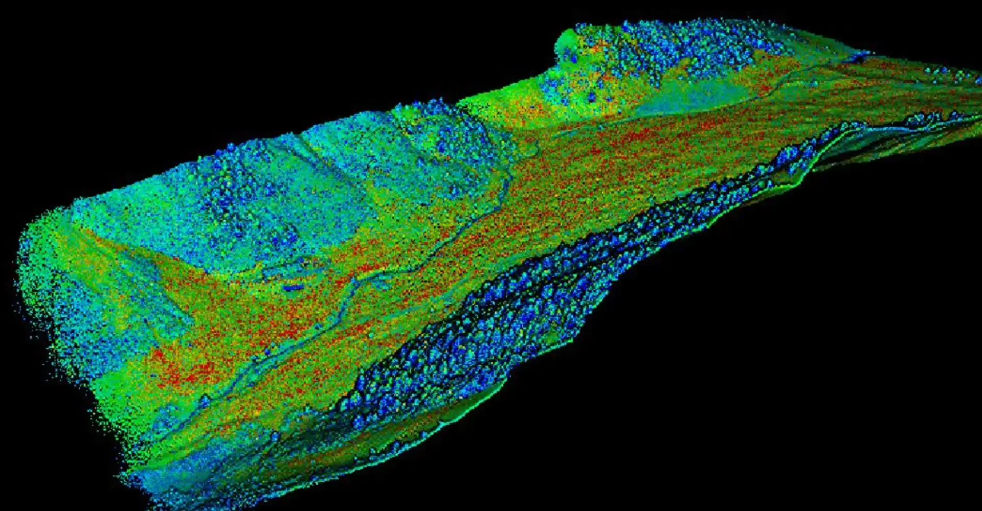
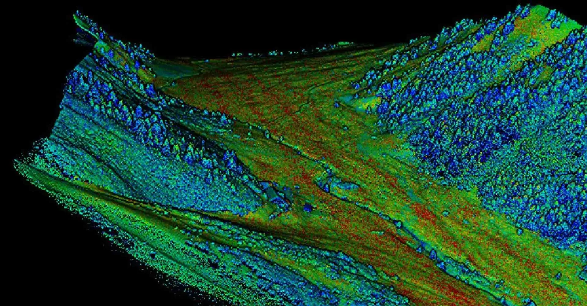
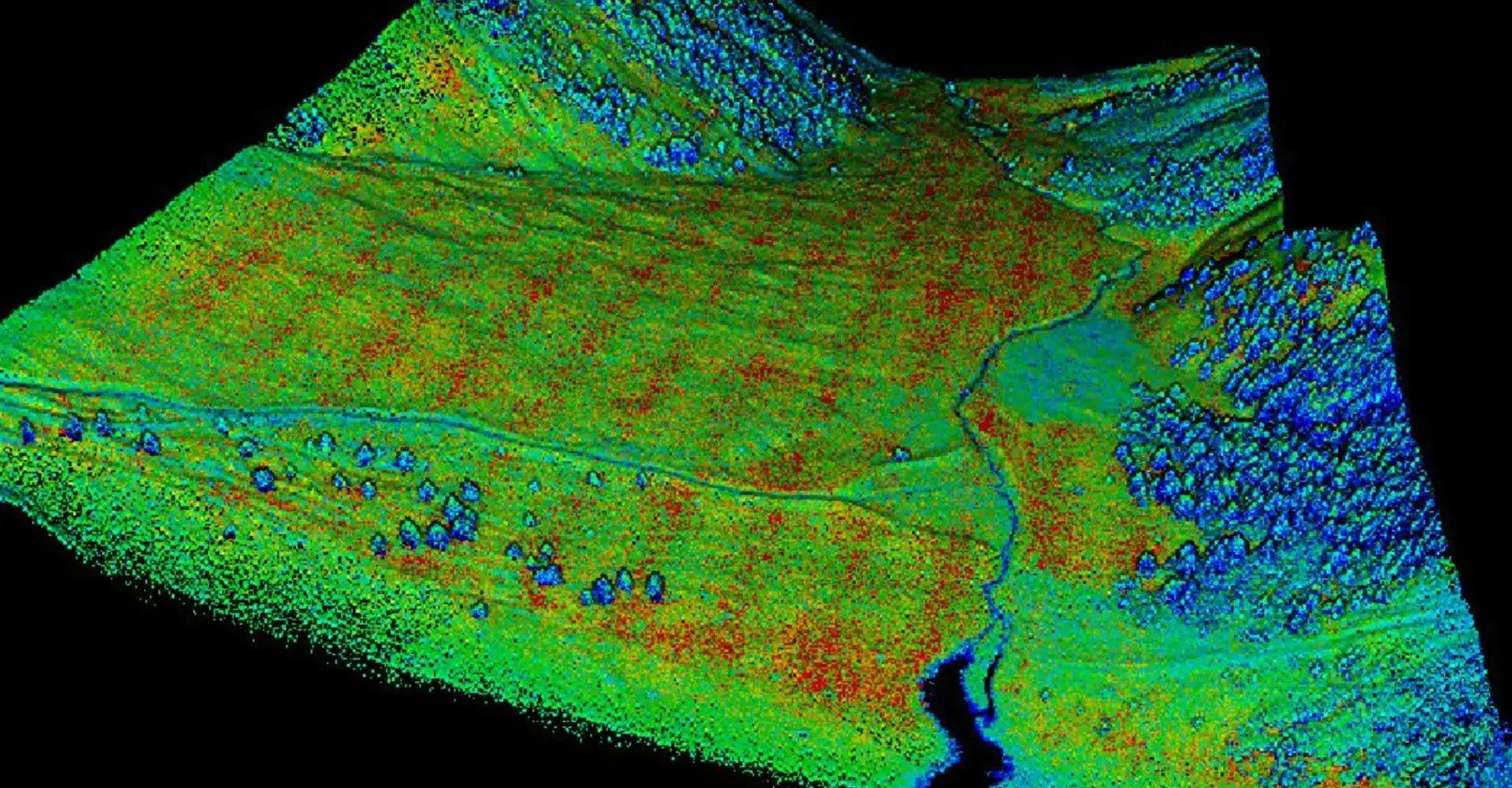
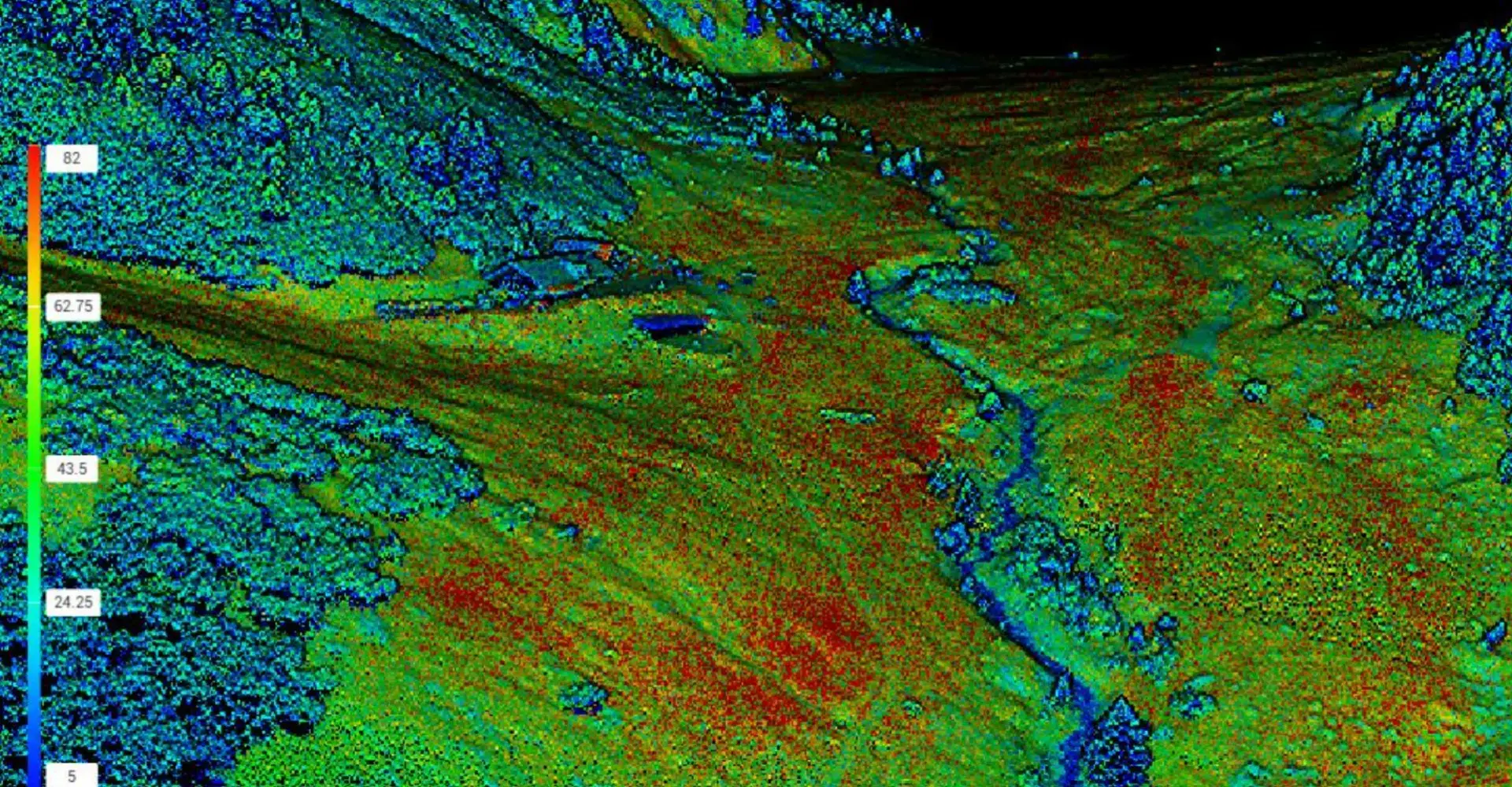
Matrice 350 RTK with Lidar L1 for Long Range Scan
The Matrice 350 RTK is equipped with an L1 Lidar sensor and a P1 photogrammetry camera.
The Zenmuse L1 integrates a Livox sensor, high-precision IMU, a 20 MP one-inch CMOS visual camera with a mechanical shutter, and a 3-axis stabilized gimbal system.
It can be utilized across a wide range of vertical sectors, including energy, AEC (Architecture, Engineering, and Construction), forestry, public safety, and more.
This all-in-one solution offers great versatility, allowing for the capture of detailed and precise data with ease.
With the capability to cover an area of 2 km² in a single flight, at a flight speed of 10 m/s and a flight altitude of 100 m, this drone provides a 20% side overlap ratio. Additionally, it offers vertical accuracy up to 5 cm and horizontal accuracy up to 10 cm with a flight altitude of 50 m.
Thanks to its ability to capture a high-density point cloud, with 240,000 effective points per second, and support for multiple returns, up to three returns (dual and triple), with a point cloud density of 480,000 points per second, this drone provides detailed and accurate data in any scenario.
Its weather resistance, with an IP44 rating, allows operators to collect data even in adverse weather conditions. And thanks to its integration into the DJI ecosystem, data processing is made simple and efficient using DJI Terra.


The Zenmuse L1 integrates a Livox sensor, high-precision IMU, a 20 MP one-inch CMOS visual camera with a mechanical shutter, and a 3-axis stabilized gimbal system.
It can be utilized across a wide range of vertical sectors, including energy, AEC (Architecture, Engineering, and Construction), forestry, public safety, and more.

The Zenmuse P1 features a 35.9×24 mm full-frame sensor for photography, and 34×19 mm for video recording.
It supports three types of lenses: DJI DL 24mm, 35mm, and 50mm F2.8 LS ASPH. As for video format, it supports 4K recording at 60fps.
Lidar Module
RGB Camera
High-precision IMU: vertical - 5 cm; Horizontal - 10 cm (with a flight altitude of 50 m)
It covers 2 km² in a single flight: flight speed 10 m/s, flight altitude 100 m, 20% side overlap ratio
High-density point cloud: 240,000 effective points/s
Multiple returns: dual and triple returns, point cloud density 480,000 points/sec
Measurement range: 450 m maximum (80% reflectivity 0 klx)
Real-time point cloud visualization
Weather-resistant: IP44 rating
DJI ecosystem: DJI Terra
Professional 3D Aerial Scans
Starting from a point cloud, any type of land scan can be modeled and adapted as needed.
This technology allows for the inclusion, modification, and recreation of spaces and environments within a cinematic scene that do not exist in reality.
The equipment is dedicated to both scanning buildings and entire outdoor spaces, at medium and long ranges.